Bath Skyline Walk
Bathwick, Bath and North East SomersetWalks in Somerset

- Distance
- 5.8 miles
- Time
- 2 hr 40 min
- Climb
- 674 ft
- Route
- Circular
- Difficulty
- Moderate
About this walk
A moderate 5.8-mile loop around Bathwick, about two and a half hours.
This 5.8-mile loop starts in Bathwick and runs clockwise around the high ground above Bath, usually taking just under three hours. You get wide views across the city, and it's the way open countryside sits right beside Bath that helped earn the area its World Heritage Site status. Expect a mix of roads and surfaced paths, steep hills adding up to about 674 ft of climbing, a rocky, uneven stretch, some steps and two stiles. There's a café and a Tesco Express close to the start. It suits fairly fit walkers wanting a moderate half-day outing.
Route waymarked by National Trust, mapped by OpenStreetMap contributors.
Near the start
- Café
- Sixth Form Cafe, 350 m from the start
- Shop
- Tesco Express, 600 m from the start
- Stiles
- 2 mapped on the route
- Woodland
- About 40% of the route
Good to know
- Hills
- Flat
Photos
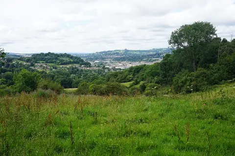
Hillside below the Bath Skyline walk — Photo: Bill Boaden, CC BY-SA 2.0 (Wikimedia Commons)
More walks near Bathwick
Long Ashton Village Circular Walk
Long Ashton · 14.5 miles away
5.6 miles · 2 hr 35 min · Circular
- Circular
- Café or pub nearby
- No stiles

Circular from Wotton-under-Edge via Tyley Bottom, Ozleworth and Newark Park
Wotton-under-Edge · 17.6 miles away
7.2 miles · 3 hr 15 min · Circular
- Circular
- Café or pub nearby

Avebury Ridgeway Walk
Avebury · 21.1 miles away
5.3 miles · 2 hr 15 min · Circular
- Circular
- Café or pub nearby
- No stiles

Bruce Trail Friendship Trail
Whiteshill · 27.1 miles away
6 miles · 2 hr 55 min · Circular
- Circular
- Woodland
Bishton & Llanwern Loop
Bishton · 27.2 miles away
3.1 miles · 1 hr 25 min · Circular
- Circular
- No stiles

Newport Wetlands & Goldcliff Loop
Nash · 28.9 miles away
6.7 miles · 2 hr 45 min · Circular
- Circular
- Coastal
- Café or pub nearby
Walk Bath Skyline Walk with Lead On
Save it to your walks and Lead On will suggest it on a day it suits: the right weather, the right tide and the time you have. It tracks the route as you go, even with your phone locked.