Blakeney Circular Walk
Blakeney, NorfolkWalks in Norfolk

- Distance
- 7.5 miles
- Time
- 3 hr 10 min
- Climb
- 282 ft
- Route
- Circular
- Difficulty
- Moderate
About this walk
A moderate 7.5-mile loop around Blakeney, about three hours.
This 7.5-mile circular walk begins in Blakeney and loops through Cley next the Sea, linking two of Norfolk's coastal villages. Along the way you'll get wide views over grazing marshes, and the route rises up to Wiveton Down Nature Reserve, the higher land on this stretch. Total climbing is around 282 ft, so expect some uphill work, and allow about three hours and ten minutes. It's a moderate walk that suits reasonably fit walkers looking for a varied half-day out.
Route waymarked by Norfolk Trails, mapped by OpenStreetMap contributors.
Near the start
- Dog-friendly café or pub
- The Three Swallows, 1.4 miles from the start
- Café
- Two Magpies Bakery, at the start
- Pub
- Blakeney Hotel, at the start
- Shop
- Blakeney Delicatessen, 150 m from the start
- Toilets
- The Quay Toilets, at the start
- Stiles
- None mapped on the route
Good to know
- Hills
- Flat
Photos
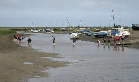
Channel crossing at Blakeney — Photo: Dave Croker, CC BY-SA 2.0 (Wikimedia Commons)
More walks near Blakeney
Circular Walk from Morston Quay to Cockthorpe
Morston · 1.5 miles away
6 miles · 2 hr 30 min · Circular
- Circular
- Coastal
- Café or pub nearby
Sheringham Circular
Upper Sheringham · 7.9 miles away
6.8 miles · 3 hr · Circular
- Circular
- Coastal
- Café or pub nearby
Burnhams Circular
Burnham Overy · 11.4 miles away
4.5 miles · 1 hr 55 min · Circular
- Circular
- Coastal
- Café or pub nearby
Gressenhall/Beetley Circular
Beetley · 17 miles away
4.5 miles · 1 hr 50 min · Circular
- Circular
- Café or pub nearby
- No stiles
Swanton Morley Circular
Swanton Morley · 17.1 miles away
3.2 miles · 1 hr 20 min · Circular
- Circular
- No stiles

Ringstead Circular Walk
Ringstead · 20 miles away
7 miles · 3 hr · Circular
- Circular
- Café or pub nearby
Walk Blakeney Circular Walk with Lead On
Save it to your walks and Lead On will suggest it on a day it suits: the right weather, the right tide and the time you have. It tracks the route as you go, even with your phone locked.